 K K Geo System | 3D Scanning & Metrology Solutions India
Precision 3D Laser Scanning & Dimensional Metrology Solutions
K K Geo System | 3D Scanning & Metrology Solutions India


Engineering services
K K Geosystem provides laser-scanning-based tank geometry capture, volume-chart preparation and agreed inspection reporting.
Our offices in Ahmedabad and Jamshedpur support on-site assignments across India. The proposal defines capture, processing and reporting responsibilities for your requirement.
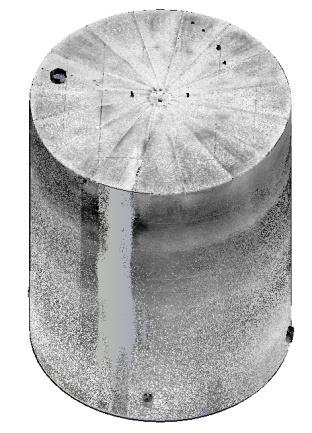
Our tank portfolio includes underground FRP tanks and edible-oil storage tanks. We capture the agreed geometry and prepare volume information and inspection reports within the defined measurement scope.
Deliverables, formats and checks are agreed for each assignment.
The project profile records underground and above-ground storage-tank assignments. Any required certification, acceptance standard or regulatory scope must be established before quotation.
Send tank type, dimensions, accessibility, service condition, required chart or report and applicable acceptance requirements.
| Your inputs | Our agreed work | Delivery |
|---|---|---|
| Tank geometry, access, datum and chart requirements | Accessible geometry capture and scoped volume calculations | Agreed volume or calibration chart and report |
Internal obstructions, inaccessible geometry and the selected level reference affect the calculation basis and must be addressed in the scope.
The chart relates levels to calculated volumes within the agreed geometry and reference system. Its basis, units and scope must accompany the result.
Do not assume so. Any certification or regulatory requirement must be identified and confirmed separately before commissioning.
Start with a non-sensitive summary of the requirement. Agree NDA conditions and a suitable transfer method before sharing restricted files. Public project descriptions do not need to identify the end-customer.
Offices in Ahmedabad and Jamshedpur. On-site services across India. Remote modelling and drawing services for overseas customers using customer-supplied data.
Email inquiry@kkgeosystem.com or call +91 98244 40077.
Please include the service required, location, approximate size or data extent, required outputs and target date. For confidential or large files, contact us to agree the transfer method.